
Esposende and the Sea (T3 Grant)
Ivone Magalhães, Ana Almeida, Richard Furuta, Filipe Castro, Anna Linderholm
Introduction
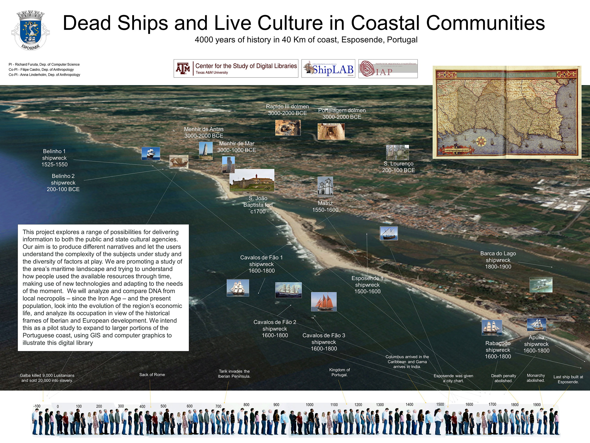
Esposende has been a Portuguese city since 1993, and has a population of around 34,000. Located on the coast, it has a long standing connection with the sea. Although the region has been occupied since the Paleolithic and is rich in archaeological remains, Esposende was sparsely inhabited throughout the Middle Ages and was only granted a charter as a village in 1572, by king D. Sebastião (1554-1578). The population of Esposende grew slowly, from around 4,000 inhabitants in 1800, to slightly above 30,000 in 2000. The region was continuously inhabited through the Roman and Medieval periods.
The Texas A&M involvement with this municipality stems from the Belinho 1 project, the study of a 16th-Century shipwreck that has partially washed ashore at Belinho beach, and is being studied as a long-term project by an international team.
Given the wealth of archaeological (and anthropological) information available, we decided to develop a project to share in several different ways. Our ultimate goal is to create a dynamic historical map that conveys the stories of the peoples that lived in this landscape from as many viewpoints as possible. When we look at the area and the diversity of peoples that seem to have occupied it in the last 20,000 years, we believe that is worth trying to tell their story in a simple and accessible way, worth trying to understand their relation with the environment and the ways in which their subsistence patterns influenced their worldviews.
During the last 20,000 years, the coastline moved around 40 Km east, profoundly changing the landscape, the fauna, the climate, the subsistence patterns, the carrying capacity of the area, and the ways of life of its inhabitants. Geological studies suggest that the coastline stabilized around 3,000 BCE, in the Neolithic.
This project is a work in progress and it is unlikely that this webpage will ever be completed. We expect it to change quite often, and at this point we are considering the format options to illustrate the texts with maps and images without making it too long, to complicated, or too confusing. Our intended audience are first the local and visiting public, the stake holders that are the guardians of the region’s cultural heritage. But we would like that this site be a good learning environment for people around the world to enjoy the story of Esposende and to understand that the social value of archaeology is in the personal interpretations of the data related below. Archaeology is an adventure into human history, providing landscapes on which we can imagine living. In doing this, it aids us to better understand ourselves.
Team
The team integrates faculty and students from the Departments of Computer Science, Visualization, and Anthropology at Texas A&M University, and archaeologists Ivone Magalhães and Ana Almeida from the Esposende municipality.
Archaeology
As mentioned above, we propose to develop a set of computer tools which will present Esposende’s maritime landscape to a wide public, from as many viewpoints as possible, thus giving voice to those who traditionally remain silent in the villages’ histories.
Our methodology is to map the region, tag the sites in terms of their function and meaning, develop a GIS-based chronology of the occupation, and try to understand how this landscape has been perceived and used through time by the local population, visitors, neighbors, and foreigners.
This region has been occupied since the Paleolithic. Traces of human occupation have been recorded through the last centuries, and provide us with a rich set of data to develop this experimental project.
The earliest inhabitants
It is likely that the area where now lies Esposende was continuously inhabited during the last 20,000 years. Around 12,000 years ago, the end of the last Ice Age triggered a rise of the sea level, and the actual coast of the region was created around 100 m above the previous levels, and about 40 Km distant from the lowest waterline. During the Little Ice Age (1300-1800), a dune system formed along this stretch of the coast, covering a thick layer of cobble stones that may indicate the presence of a river (Almeida and Magalhães 2013).
As mentioned, the coastline seems to have stabilized around 3,000 years BCE. In the last decades, a process of transgression has destroyed the sand beach that covered the zone and has continued destroying the dune system, exposing lower layers of the stratigraphy and revealing several levels of human occupation.
An interesting collection of stone tools – picos asturienses – has been found in the region, namely at Praia de Rio de Moinhos, on the bottom of the Aguçadora Formation, a silted area that corresponded intermittently to a lagoon in the Holocene (Monteiro-Rodrigues, 2013). Radiocarbon dates place this lithic production into two intervals: circa 4615-4320 BCE, and circa 3622-3024 BCE.
It is likely that the region remained occupied through the Neolithic. Stone tools from both the Acheulean period and the Holocene picos asturienses, dated to the Epipaleolithic and believed to be associated with the consumption of mollusks, have been retrieved from this area. A number of Neolithic monuments, dated to the fourth/third millennia BCE (3,800/3,700 to 2,700/2,500 BCE), pepper the landscape and attest its occupation during this period. Megalithic monuments – tombs and phallic monuments – continue into the Calcolithic and up to the late Bronze Age (Brochado de Almeida 2013, 36-45).
Chalcolithic
During the late Neolithic and the Portuguese Copper Age (the 3rd millennium BCE) this region was occupied by small settlements without protective walls, located in the plains, presumably surrounded by agricultural gardens.
In Portugal the Chalcolitic is a chronological-cultural stage marked between the end of the IV millennium and the third quarter of the III millennium BC, where significant changes in community interaction with the environment took place. Throughout this period there is the appearance of occupations on plateaus, granitic alveoli or tops of medium altitude spurs, or on hills of valleys or of the coastal platform. Such settlement strategies will be closely related to the potential development and diversification of subsistence activities, as well as symbolic factors. It also reveals a higher occupational density, a longer occupation period of each place and the increase of a more surplus way of life of agropastoral activities, maintaining practices of collection/harvest and the use of fluvial and coastal resources.
A Chalcolitic settlement was located near Monte da Cerca, on a rugged place full of boulders, but with a view over the coast and the sea, and a view over the nearby fertile plains. Another of these settlements was located near Bitarados. Yet another settlement was probably located at Maindos, as suggested by Calcolithic ceramics. The forth and last of the unprotected settlements was located at Gandra, in Bouça do Senhor farmland.
A necropolis was located at Quinta de S. Martinho, and circa 20 burial mounds (mamôas) pepper the area and a site on the border between Gemeses and Vila Chã.
Bronze Age
The Portuguese Bronze Age is a chronological and cultural period marked between the end of the III millennium BC up until the second quarter of the I millennium BC – around 2,000 BCE and the end of the 7th century BCE. It is subdivided into three phases: Early Bronze Age, Intermediate Bronze Age and Late Bronze Age. It is characterized by the circulation of new ideas, goods, techniques and skills, possibly associated with the exchange of metals – such as copper, gold and silver – and the change in the symbolism of artifacts produced out of these materials, now handled by local communities. However, it is throughout the first half of the II millennium BC that bronze metallurgy is adopted. Like its copper counterparts, the earliest bronze artifacts would remain symbols of prestige and power. Turning stone into metal and successfully creating alloys, would have given a profound and special characteristic to the protagonists of the metallurgical activity, to the object itself and to the mining sites.
In terms of settlement strategies, the number of residential sites increases and some changes occur indicating new forms of interaction and structuring of populations throughout the territory. If, on one hand, the previous characteristics are maintained, on the other, the tendency towards the emergence of new dynamics is consolidated. This paradigm is reflected in the development of settlements in high spurs, bordering agricultural valleys or the coastal platform, with excellent visibility conditions over the territory. In coastal areas, in the lowlands and in some plateaus or slope areas, cist necropolises, mostly consisting of flat open graves in the ground, are sometimes located in the vicinity of villages.
The Esposende area conserves an important set of megalithic (funerary) monuments, as well as one menhir. Its archaeological importance in the region was understood in the 19th century, when the first sites were object of archaeological interventions. It seems that during the Bronze Age the population in this area did not change its subsistence patterns – farming and herding, hunting, fishing, and collecting mollusks – but started mining the landscape. There were gold and tin on the hills of Palmeira, the Cávado River sands, and the alluvial strata of Lagoa Negra.
The most important vestiges are settlements located in protected places and sometimes surrounded by protective walls. It seems that the region’s mining activity generated an elite that could afford the protection of the newly built settlements.
The most interesting of these settlements are the Castro de São Lourenço and the Castro do Senhor dos Desamparados. The first was occupied in the Bronze Age as suggested by the findings of a bronze axe and ceramics dated to this period, and the second dated by the existence of silos, a funerary structure, and Late Bronze Age ceramics.
Castro da Cova da Bouça
The Castro Cova da Bouça (Belinho) stands on an impressive elevation that stands out on the coastal platform, observable from a great distance and surely used as a point of reference in coastal navigation. In the Northwestern slope, between granite rock formations, a group of metallic bronze elements composed of a Bujões/Barcelos type ax, a flat ax and an argaric sword was recovered.
São Paio de Antas Menhir
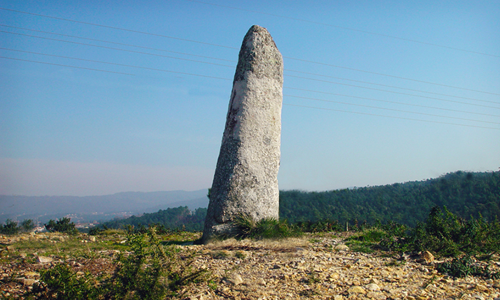
Dating to the 3rd millennium BCE, this granite menhir stands 1.65 m tall near the local church. It is one of three still standing in the region – the other two being located in São Bartolomeu do Mar and Forjães – and it is located near a settlement which could have coeval roots.
With a phallic shape, this menhir is not decorated and is thought to have been associated to a fertility cult. Common in Western Europe, many menhirs and megalithic monuments were destroyed after the Christianization of the region.
Castro de S. Lourenço
The Castro of S. Lourenço (Vila Chã – Marinhas) is another example of a village that appears in this period, situated on the coastal platform, with excellent visibility and control over the territory.
Linhariça / Susão
In the coastal areas, in the lowlands and in some plateau or slope areas, there are cist necropoli, in the vicinity of which villages could be located, such as the village of Linhariça / Susão (Palmeira de Faro).
Linhariça / Susão
In the Esposende territory, for example, we find the Necropoli of Linhariça / Susão – framed in the Early / Intermediate Bronze Age.
Belinho and Agra de Antas
The cist necropoli of Belinho (S. Paio de Antas) and Agra de Antas (S. Paio de Antas) – incorporated in the Intermediate Bronze Age.
Monte / Talhóz, Terroso, and Vilar
The tombs of Monte / Talhóz (S. Paio de Antas), of Terroso (Palmeira de Faro) and Vilar (Curvos) graves – associated with the Intermediate / Late Bronze Age.
Curvos, Rio (Marinhas) and the necropolis of Terroso / Sr. Desamparados
Cist of Curvos, the tomb of Rio (Marinhas) and the necropolis of Terroso / Sr. Desamparados (Palmeira de Faro) – attributable to the Late Bronze Age.
Iron Age
In Portugal the Iron Age is a chronological-cultural stage marked between the 9th century BC and the 1st century AD, and can be generically assigned the following subdivision:
Late Bronze Age – 1st Iron Age | 9th century BC to the 7th century BC – formation of the Castro Culture in the Atlantic context, with continental and Mediterranean interactions. Implementation of hilltop villages, in coexistence with open villages.
1st Iron Age | 7th century BC up to the 5th century BC – development of the Castro Culture, with the consolidation of the occupation of the territory, characterized by the construction of circular buildings with perishable elements and the beginning of the creation of defensive systems. This phase coincides with the “Turduli” migrations – which may have promoted the development of indigenous communities, guided by Mediterranean influences – the contact with Punic trade and early Italian imports.
2nd Iron Age | 6th century BC up to the 3rd century BC – peak of the Castro Culture, with the beginning of the petrification of villages, with the introduction of buildings erected with small stones, covered with perishable elements.
2nd century BC to the 1st century AD – decline of the Castro Culture and the advent of Romanization, coinciding with the first direct contacts with the Romans. It is from the second half of the I millennium BC, coinciding with the peak of the Castro Culture, that local communities adopted and developed iron metallurgy, applied to the most diverse socioeconomic areas.
The majority of habitats in the present Esposende territory are spread over a territory that is far from uniform. The innermost landscape consists of plateaus or is guided by a succession of small reliefs crisscrossed by valleys of variable sizes, that at the time were covered by dense patches of forest, thick vegetation, cut by dirt roads. In contrast the slopes and ridges of the fossil cliff and the ridges of the innermost relief were covered with undergrowth where the gleaming boulders emerged. The shoreline provided a vast patch of arable land, marked by small marine lagoons near the shoreline, but that were only truly harnessed during the dawn of Romanization.
Faced with this reality, on the North coast, on the most defensible reliefs of the granitic cliff the Cividade de Belinho (S. Paio de Antas), the Castro Cova da Bouça (Belinho), the Castro de N. Sra. da Paz (Marinhas) and the Castro de S. Lourenço (Vila Chã-Marinhas) emerged. On the South coast of the Cávado River, the absence of adequate orography led to the retreat of the Iron Age populations to more interior and southern reliefs such as the Castro do Sr. dos Desamparados (Palmeira de Faro) and the Castro do Outeiro dos Picoutos (Fonte Boa). In contrast to these high altitude fortified settlements, there were also small habitats from the late Iron Age, such as the one in the vicinity of the Parish Church of Forjães and in the place of Monte / Talhóz (S. Paio de Antas).
The Castro de São Lourenço
Was inhabited from the 4th century BCE to the 4th century CE, and reoccupied in the 14th century. (refs here)
The Castro do Senhor dos Desamparados
Was inhabited through the Iron Age and Roman periods. It was a small village protected by walls. (refs here)
Megalithic Necropolis of Vila Chã
Dating to the … this site was first excavated in the late 19th century and (refs here)
São Bartolomeu do Mar Menhir
https://www.visitesposende.com/en/fazer/roteiros/archeological-tour (refs here)
Arribadas Dolmen
https://www.visitesposende.com/en/fazer/roteiros/archeological-tour (refs here)
Portagem Dolmen
This is a funerary monument dated to…
https://www.visitesposende.com/en/fazer/roteiros/archeological-tour
Rapído III Dolmen
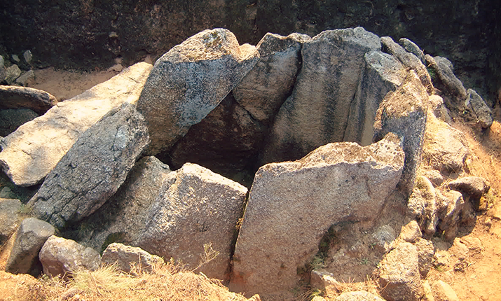
This complex includes three megalithic tumuli. It has been dated to… (refs here)
(refs here)
The Roman Period
There are some vestiges from the Roman period in this area. Even though the thickness of the sediments is generally thin, Roman tegulae and amphora shards attest to the existence of some kind of occupation in the area of present day Esposende during this period.
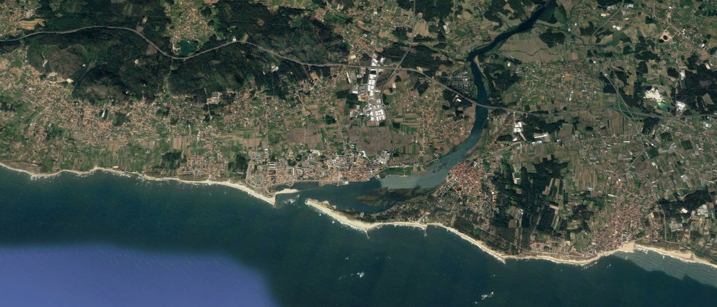
We also know that a roman road passed near the Barca do Lago area, where the river Cávado was probably crossed by boat, and there may have existed a temple – fanum – where now is Fão.
Furthermore, undated old graves with ceramic materials were found near the site of today’s chapel of Nossa Senhora da Saúde, which replaced an older chapel of São Sebastião, suggesting that this may be a local of continuous worship.
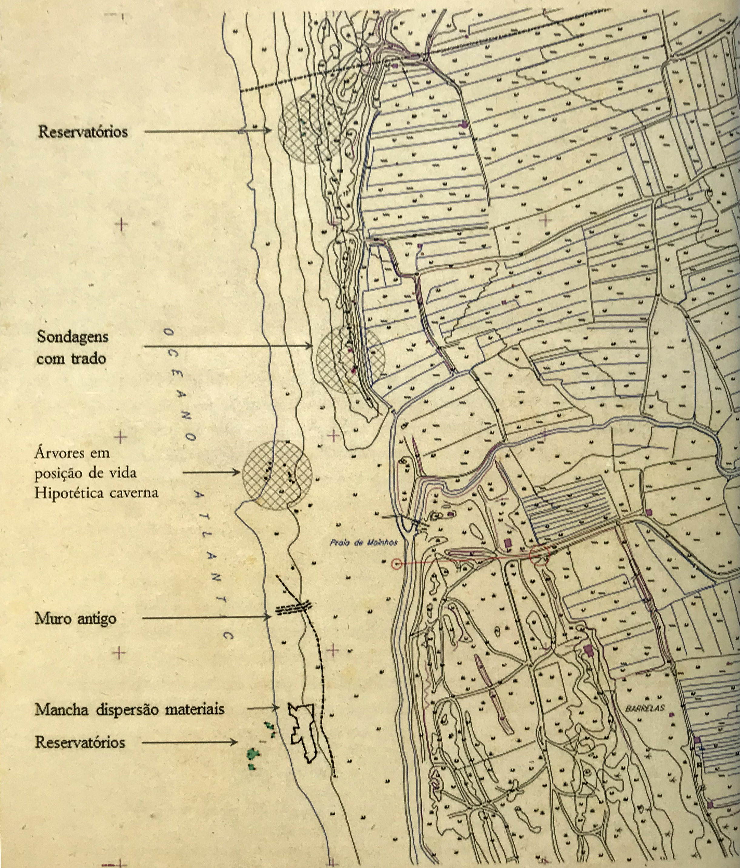
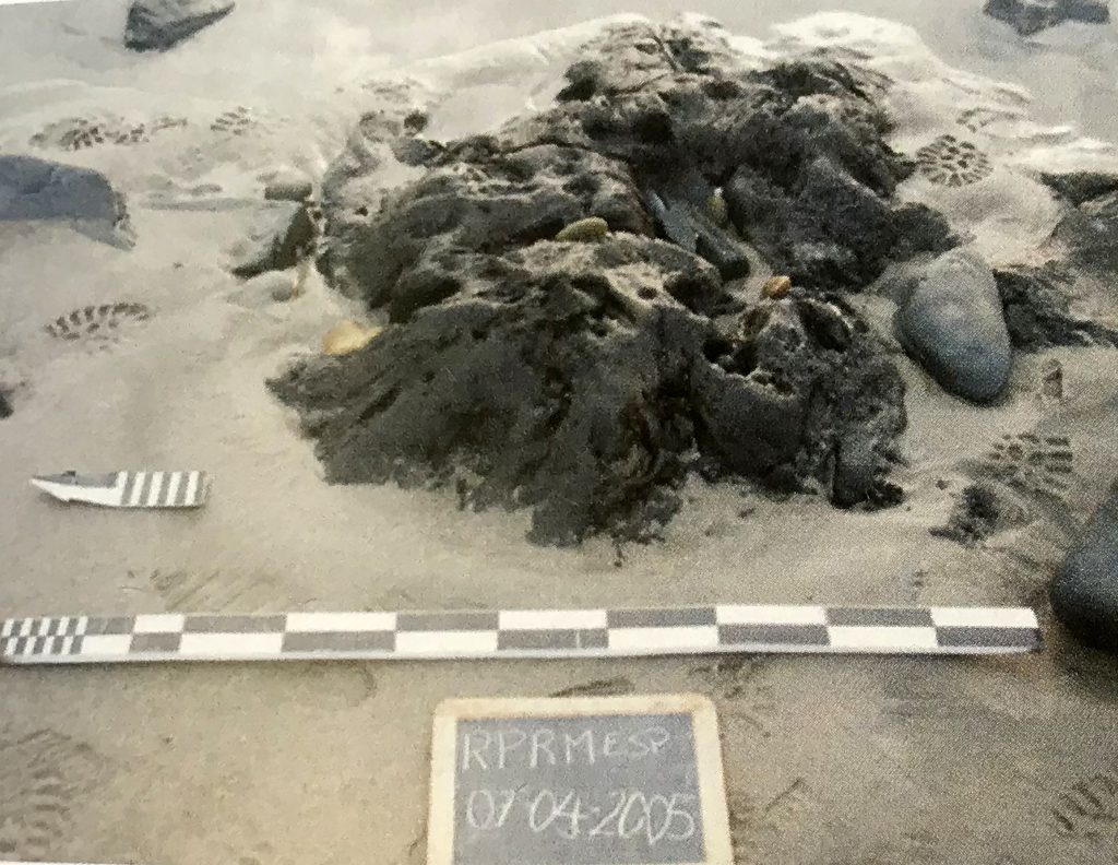
Ribeira do Peralto
An exceptionally low tide exposed an area with ceramics and shale weights at Ribeira do Peralto, in the winter of 2005. Alerted to the importance of this site by its finder, Ricardo Soares Abreu, a closer inspection of this area revealed a rich archaeological complex, which encompassed the remains of a wall, large rectangular depressions excavated in the shale, in the shape of reservoirs or salt pans, and a concentration of ceramic shards that seems coherent and compatible with the occurrence of a shipwreck in the area, dating to about xxxx. In all, circa 1,460 ceramic shards were recovered and handed to the Esposende municipality. In the area of approximately 50 m², where the ceramic fragments were found, there were
Some 10 timber fragments with 2 to 4 m were also reported in the area, buried in a silty layer beneath the sand. One of the timbers looked like a ship frame. Shale weights, probably from nets, were also abundant in this area.
In the subsequent years another area with reservoirs excavated in the shale was surveyed to the north of this site. Some of the reservoirs were connected by channels carved on the shale.
Between the two areas of reservoirs excavated in the shale the survey team observed an old silty layer with tree stomps – some with cut marks – that was later dated to circa 6,000 BP, possibly corresponding to the same area found at Rio de Moinhos and mentioned above.
In the winter of 2012 and 2013 a number of grinding stones were found in the sea off Praia do Peralto by diver Mr. Manuel Silva.
Additional finds in the area probably belong to a later period and encompass a timber that may have belonged to a ship, and an olive jar, typical of the late 16th century.
The Middle Ages
Between the 9th and 14th centuries new areas are populated and previously occupied spaces persist. In the area of Monte de S. Lourenço and in various beaches along the coast fishing weights have been recovered and salt pans have been found. Some of these are depressions carved on the rock surfaces, as is the case of the Neiva (S. Paio de Antas) and Peralta (Marinhas) river-mouths.
Medieval documents also attest to the existence of salt production since the 10th century. The earliest document that mentions salt production is dated to AD 959 and belongs to the Mumadona Codex. It mentions “saliniense salinas” at vila de Fão, situated near Cávado river and close to the sea (…vila nuncupata fano (…) erga anne catavo (…) ab ore maris…).
Early Portugal
The medieval medieval cemetery of Barreiars, Fão, conserved 144 graves, dated from the 11th to the 14th centuries. Skeletal remains were studied (refs here) and artifacts found in association with the graves – king Sancho II Dinheiros (1223-1248), ceramics, and fishing weights – illustrate the village relation to the sea.
The Early Modern Period
From 1500 to 1700 the history of the region is better documented. Esposende urban area starts its consolidation in this period. Always connected to the sea, the village grows and starts building watercraft and exchanging goods. Commerce is going to develop this area, in spite of its difficult river-mouth. King Sebastião (1554-1578) grants the village a charter and the traffic in and out of the Cávado river increases significantly.
A number of shipwreck sites has been found along the coast of Esposende, including the Belinho 1 shipwreck, dating to the first half of the 16th century.
References
Almeida, Ana Paula R. A. R. Brochado de, 2005. Relatório dos Trabalhos Arqueológicos. Praia do Ribeiro de Peralta [Rio de Moinhos – Marinhas – Esposende], Esposende.
Almeida, Ana Paula; Magalhães, Ivone, 2013. O achamento da praia da Ribeira do Peralta (Esposende – Noroeste de Portugal), “O Irado Mar Atlântico. O naufrágio bético augustano de Esposende (Norte de Portugal)”, p. 11-26;
Almeida, Carlos Alberto Brochado de, 2013. O concelho de Esposende: da pré-história à antiguidade clássica, “O Irado Mar Atlântico. O naufrágio bético augustano de Esposende (Norte de Portugal)”, p. 27-55;
Bettencourt, A., 2013. “Conjunto megalítico do planalto de Vila Chã, Esposende” in The Prehistory of the Northwestern Portugal. Braga: CEIPHAR/CITCEM.
Granja, Helena, Monteiro-Rodrigues, Sérgio, Danielsen, Randi, 2016. Changing environments and Human settlement during Mid-Holocene in Rio de Moinhos Beach (Esposende, Northern Portugal), “Estudos do Quaternário”, 14, APEQ, Braga, pp. 25-40;
Monteiro-Rodrigues, S., 2013. A indústria macrolítica holocénica da praia de Rio de Moinhos (Marinhas, Esposende, NW de Portugal). Apresentação de um estudo preliminar / The Holocene macrolithic assemblage from Rio de Moinhos beach (Marinhas, Esposende, Northwestern Portugal). A preliminary study, “GALLÆCIA”, 32, p. 87-108,
Morais, Rui, 2013. Um naufrágio bético, datado da época de Augusto, em Rio de Moinhos, “O Irado Mar Atlântico. O naufrágio bético augustano de Esposende (Norte de Portugal)”, p. 309-334;
Morais, Rui; Granja, Helena; Oliveira, César, 2016. Baetic shipwrecks in the coast of Esposende (North Portugal) / Naufrágios béticos en la costa de Esposende (norte de Portugal), “Actas del V Congreso Internacional de Arqueología Subacuática Un patrimonio para la humanidad”, p. 556-565;
Neves, Isabel C.; Fonseca, António M.; Oliveira, César; Parpot, Pier; Kuzniarska-Biernacka, Iwona; Morais, Rui, 2013. Caracterização de fragmentos cerâmicos oriundos do naufrágio Bético Augustano de Esposende, “O Irado Mar Atlântico. O naufrágio bético augustano de Esposende (Norte de Portugal)”, p. 247-261;
Oliveira, César; Kuzniarska-Biernacka, Iwona; Parpot, Pier; Neves, Isabel C.; Fonseca, António M.; Morais, Rui, 2013. Análise química de resíduos orgânicos de ânforas do naufrágio bético de Esposende, “O Irado Mar Atlântico. O naufrágio bético augustano de Esposende (Norte de Portugal)”, p. 263-281;
Rodrigues, S., Lopes de Sousa; Morais, R.; Helena Granja; Randi Danielsen; César Oliveira, Almeida, C., 2013. Uma abordagem multidisciplinar ao sítio arqueológico da Praia de Rio de Moinhos – Esposende, NW de Portugal/ A multidisciplinary approach to the archaeological site of Praia de Rio de Moinhos (Esposende – Norwestern Portugal), “V Jornadas do Quaternário – 5th International Conference – O Quaternário da Península Ibérica: Abordagens Metodológicas e Linhas de Investigação” – Livro de Resumos/ Abstracts Book, pp. 44-45;
Websites
https://www.visitesposende.com/en/fazer/roteiros/archeological-tour (accessed Jan 2020)
Sample section with multiple blocks
Lorem ipsum dolor sit amet, consectetur adipiscing elit. In pulvinar ex quis euismod consequat. Sed in convallis est, vel hendrerit nunc. Mauris vel quam vel arcu rutrum hendrerit. Duis et eros ac dolor posuere auctor. Phasellus iaculis, turpis nec commodo ornare, quam nisl pretium purus, in bibendum ex velit vitae nunc. Maecenas viverra erat id ultricies lacinia. Aenean congue feugiat leo, at elementum nibh fermentum at. Fusce sed purus eget orci laoreet bibendum scelerisque ut velit. Etiam in dui nec velit dictum laoreet id vitae risus. Aenean sit amet lorem lectus. Ut posuere risus placerat, placerat ex non, bibendum nisl. Etiam eu nunc vitae felis congue interdum scelerisque et tortor. Morbi eleifend et neque ac interdum. Ut at semper elit. Pellentesque in lectus hendrerit, venenatis turpis sed, cursus nibh. Pellentesque porttitor nunc quis risus iaculis, nec semper erat blandit.
Lorem ipsum dolor sit amet, consectetur adipiscing elit. In pulvinar ex quis euismod consequat. Sed in convallis est, vel hendrerit nunc. Mauris vel quam vel arcu rutrum hendrerit. Duis et eros ac dolor posuere auctor. Phasellus iaculis, turpis nec commodo ornare, quam nisl pretium purus, in bibendum ex velit vitae nunc. Maecenas viverra erat id ultricies lacinia. Aenean congue feugiat leo, at elementum nibh fermentum at. Fusce sed purus eget orci laoreet bibendum scelerisque ut velit. Etiam in dui nec velit dictum laoreet id vitae risus.
Vestibulum aliquam rhoncus dui, vitae bibendum magna posuere vestibulum. Proin eu sapien luctus orci aliquam accumsan. Suspendisse eu rutrum erat, quis elementum eros. Suspendisse sollicitudin leo ac leo rutrum dignissim. Mauris gravida felis ex, in congue odio semper ac. Aenean dolor ante, mattis et eleifend sit amet, congue vel justo. Aliquam et elit volutpat, rhoncus mi vel, egestas arcu. Proin vel commodo nulla. Proin luctus ante leo. Sed et accumsan massa. Nullam sit amet nisi at ante sodales posuere. Vestibulum rhoncus felis id eros pharetra pulvinar. Sed tempus, ipsum vel hendrerit dapibus, eros velit facilisis dolor, quis ultricies ligula magna sit amet risus.