
The Bay of Cartagena de Indias is and has been a space with considerable economic and commercial importance since the Colonial period, it is a city in which a large number of sociocultural dynamics have occurred linked to local Native populations, colonizers Europeans (Spanish, French, English, etc.) and Afro and Afro-descendant communities. For this reason, the Port was immersed in several warlike confrontations that left archaeological evidence deposited in land, coastal, intertidal and underwater contexts. With the French (led by Baron de Pointis) and English (commanded by Sir Edward Vernon) sieges that occurred in 1697 and 1741 respectively, the entire Bay of the city gradually became a great battlefield that was the protagonist of multiple defensive war tactics and strategies.
In this sense, the Spanish Crown invested a large amount of economic and human resources to devise and build a defensive system that had the ability to prevent the loss of the territory by the other colonizing powers, which were interested in obtaining the geopolitical control of Cartagena de Indias. In this way, from the 16th and 17th centuries a Fortified System began to be configured, composed by different forts, batteries, and platforms located in geostrategically defined areas. Each of these responded to the only nautical access route that existed since the 17th century (before the closure of the Bocagrande entrance): The Bocachica Canal.
Therefore, around the entire Bay several defensive artillery devices were arranged to avoid (or at least delay) the enemy outposts towards the Historic Center of the city. When the battles began, these barriers, which at first acted as “defensive lines” but later became “posts for defense in depth”, were assisted by different types of vessels (ships of the line, frigates, sloops and even merchant boats) to delay foreign invasion as long as possible. This was something very difficult to accomplish, because the attacking fleets were generally accompanied by a large number of troops that surpassed the Spanish.
With all this in mind, the warlike confrontations implied that multiple fortifications and vessels were completely or partially destroyed, which led to the formation of different archaeological contexts that are preserved to this day. This, added to the large amount of isolated evidence such as bullets, weapons or nautical artifacts, historically began to structure the vestiges of a maritime war field that can be interpreted from an “Archeology of War and Battlefields”. The different archaeological investigations that have been carried out for almost two decades have made it possible to understand from an integral perspective the characteristics of this Spanish defensive system and the dynamics involved in the confrontations between the Spanish and the French (1697) and the Spanish and English (1741).
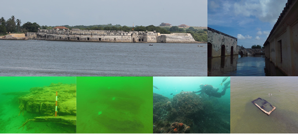

Archaeological contexts identified in the Fortified Landscape of Cartagena de Indias, among which fortifications, shipwrecks and partially and totally submerged structures can be observed
From the compilation, systematization, analysis and interpretation of different archaeological evidence from excavations and studies on military components located on the land, the coast and the seabed, it has been possible to frame all this territory in a wide and complex “Defense Maritime Cultural Landscape”, or a “Fortified Landscape”. On the other hand, thanks to the linking of information sources that derive not only from archaeology but also from history, anthropology, geography, marine biology, oceanography, hydrography, geophysics, architecture and other great diversity of social and natural sciences, it has been possible to structure protection plans for the management, investigation and dissemination of this landscape and each of the historical sites that compose it.
Some of the contexts that have been gradually identified and studied (some with more detailed analysis than others) are: the Castillo San Luis, the Forts San Fernando and San José, the Batteries of Chamba, Santiago and San Felipe, the possible shipwrecks San Felipe, África and San Carlos -1741- (which are in Bocachica); the Escollera de la Marina, the Castillo San Matías, the possible Conquistador, Dragon and Merchant ships -1741- (located towards Bocagrande); and the Castillo San Felipe de Barajas and some sectors of the Wall (close to the Historic Center of the city). Ultimately, all of these approaches have as one of their main purposes to guarantee the long-term conservation of these sites. Although, likewise, they intend to provide tools to local populations so that the heritage of Cartagena de Indias serves as an element of appropriation and use as subject to a sustainable cultural and natural development.
Bibliography
Arias, N. (2011). Arqueología de la Batería de Santiago en la Isla de Tierrabomba, Cartagena de Indias. Universidad Externado de Colombia.
Ariza, L. (2016). La mirada detrás del fuerte: Arqueología del paisaje histórico de los procesos de construcción militar colonial en Bocachica y Barú, Cartagena de Indias – Colombia. Universidad Externado de Colombia.
Del Cairo, C. (2004). Arqueología subacuática de una construcción militar del siglo XVIII en la Isla de Tierra Bomba, Cartagena de Indias: Batería de la Chamba. Universidad Nacional.
Del Cairo, C. (2009). Arqueología de la guerra en la batería de San Felipe: Isla de Tierra Bomba, Cartagena de Indias, siglo XVIII. Universidad de los Andes.
Del Cairo, C. (2011). Polyvalence, superposition et conjonction des paysages maritimes de la guerre á Bocachica au XVIIIeme siecle. Universidad Pantheon Sorbonne Paris 1.
Del Cairo, C. (2013). Entre naves y fuertes: Arqueología de las batallas costeras de 1697 y 1741 en Bocachica. Isla de Tierrabomba, Cartagena de Indias. Instituto Colombiano de Antropología e Historia (ICANH).
Del Cairo, C., Aldana, J. & Báez, V. (2020) Bocachica Bajo Asedio. Historia Militar y Política del Mundo Moderno. Revista Desperta Ferro.
Del Cairo, C., Riera, C., Báez, V., Aldana, J., Matiz, P., Garcés, J., Álvarez, P., Amórtegui, A., Rozo, L., Sánchez, C. & Rossi, V. (2020). Componente Arqueológico del Diagnóstico del PEMP Fort Bahía, Cartagena De Indias e Inmediaciones. Universidad Externado de Colombia.
Dorta, E. (1960). Cartagena de Indias: puerto y plaza fuerte. Fondo Cultural Cafetero.
Fundación Terrafirme (2017). Investigación arqueológica y de las medidas de protección, intervención y divulgación de un pecio colonial localizado en espacios subacuáticos en la zona de Bocachica, Cartagena de Indias. Instituto Colombiano de Antropología e Historia (ICANH) – Instituto Nacional de Vías (INVIAS).
García, C. & Del Cairo, C. (2006). Entre naves y fuertes: la estrategia militar de Don Blas de Lezo en 1741. Historias Sumergidas. Hacia la protección del Patrimonio Cultural Subacuático en Latinoamérica. Universidad Externado de Colombia.
Zapatero, J. (1967). Fortalezas españolas en América: “Cartagena de Indias”. Revista Geográfica Española.